Bedwell Harbour circle tour
- Richard Philpot

- Jan 11
- 7 min read
The often-benign conditions in Bedwell Harbour make this route accessible to all paddlers. Beaumont Marine Park’s driftwood beaches, the Peter Cove seal haulout, and Syrens Bistro & Lounge are highlights. So are commonly seen River otters, Bald eagles, Great Blue herons, and colourful intertidal life and wildflowers. Keep your eyes peeled for Buddha, a totem, and a “busty” mermaid.
Table of Contents
Photographs, videos, audio, and text Copyright © 2026 Richard Philpot/SGIOUTSIDE.ca.

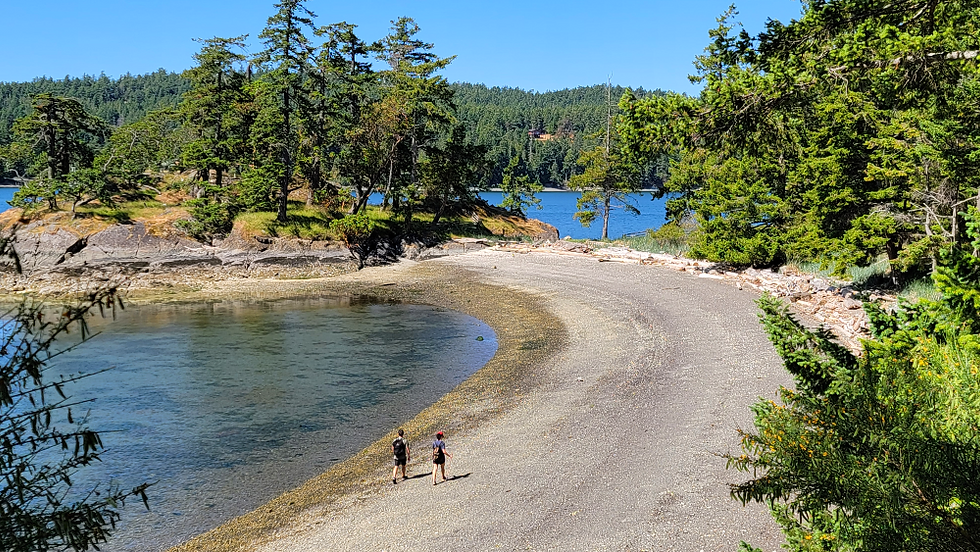
On the north side of Bedwell Harbour, Beaumont Marine Park’s driftwood-littered, crescent beach is nestled between the Beaumont Peninsula Islet and Mount Norman (040325).
BEDWELL HARBOUR CIRCLE TOUR
RP’s last time paddled: January 1, 2026.
Overview
Touring Bedwell Harbour by kayak, SUP, or other human-powered watercraft is doable for almost everyone, with the usual caveat of adequate planning and preparation. This relatively well-protected harbour offers a degree of protection from wind (and waves), and the currents are always manageable (except for the cut under the Canal Bridge between North and South Pender). The biggest dangers are inattentive power boaters transiting the harbour, coming and going under the bridge, and arriving and departing Poets Cove Resort & Spa marina (Canada Border Services Agency location). Low daytime summer tides reveal intriguing intertidal, marine, and bird life along the Beaumont Marine Park shoreline (and a splendid rotation of wildflowers from April through July). Allow extra time before or after your paddle to walk Medicine Beach and the adjacent bluff trail (041225).
Bedwell Harbour Circle Tour FACTS
Distances vary with GPS tracker devices and digital mapping software.
Tour Type: Circle tour
Difficulty Rating: MODERATE (due to the distance)
Distance (Garmin): 9-10 km (5.5-6 miles)
Time Allowance: 2.5 hours (add another 1-3 hrs if stopping for lunch at Poets Cover Resort & Spa, picnicking at Beaumont Marine Park, or climbing from Beaumont to the Mount Norman summit)
Tides: Bedwell Hbr – 7 Day/Hourly Tides (Fisheries and Oceans Canada); CHS Nautical Chart 3477
Wind predictions: Windy.com.
Dangers: Powered boats passing between North and South Pender and those entering Bedwell Harbour from Boundary Pass
Best time of year: Anytime, but it’s a bit tricky at low tides when walking on the slippery rocks in the Medicine Beach shallows
Services: Bathrooms, gift shop, restaurant and bar, coffee bar, and wine and beer store at Poets Cove Resort & Spa; Parks Canada information stations (NO camping at this time) and outhouses at Beaumont Marine Park (GINPR)
Freshwater Availability: Poets Cove Resort & Spa
Birders: Medicine Beach Nature Sanctuary—135 species since 2013 (eBird); Beaumont Marine Park—75 species since 2019 (eBird)
Launch and Parking: Medicine Beach Nature Sanctuary
Travelling to the Launch: By vehicle—2.4 km (4 minutes) from Driftwood Centre, one left turn at Wallace Road at the sharp corner east of Truss Fine Food, Medicine Beach Liquor Store, and Slow Coast Café complex, stay left down the short, rugged access road (labelled Schooner Way on Google Maps)
Launching/Landing Coordinates (Medicine Beach Nature Sanctuary): 48.76127, -123.26754

A view of the gravel beach and bird sanctuary from the Medicine Beach Nature Sanctuary’s cliffside trail originating at the commemorative plaque on the north side of the parking lot (061621).
Route Description
Launching and Landing: Medicine Beach Nature Sanctuary
Your circumnavigation of Bedwell Harbour begins at Medicine Beach. The W̱SÁNEĆ (Saanich) First Nations named the area to reflect the medicinal uses they found in various plants. Evidence of W̱SÁNEĆ summer camps was unearthed in the shell midden above the beach driftwood. A three-panel interpretive sign beside the sanctuary’s main sign and parking lot tells visitors about the area’s First Nations’ history, forage fish contribution, and ecological importance.
Medicine Beach is North Pender’s unofficial off-leash dog beach. Rare is a visit that you won’t encounter multiple breeds running or playing on shore or fetching driftwood sticks from the water. No comment on the suitability of the dog owner’s choice (I’m a dog owner), but stepping in dog shit is never fun. N.B. Permitting your pooch to enter the marsh above Medicine Beach potentially harms the habitat’s species.
Launching and landing at a tide of two metres or higher (Bedwell Harbour tide chart) minimizes the distance from your parked vehicle to the water’s edge. My preference is to launch when the tide is dropping, despite having to lug my kayak a fair distance over slimy, slippery rocks on my return. A lower tide and counterclockwise route ensure that both hauled-out Pacific harbour seals in Peter Cove and the widest variety of intertidal life are seen on Bedwell Harbour’s north side.
Ten minutes into a counterclockwise journey, you’ll paddle past an eight-acre, three-tiered, northeast-facing piece of land, mostly stripped of trees. The landowner left but a single, spindly tree on the nearshore level. Leaving a lone tree wasn’t cute. Nor was unnecessarily deforesting a piece of land the size of four soccer fields. Pay attention to the constantly changing shoreline water depths before the clear-cut and on the south side of The Timbers dock. It’s easy to get caught up on a rock or the ocean bottom when looking portside (left) across the harbour and up, searching for the Mount Norman summit observation platform.
In transit through the bay facing Poets Cove Resort & Spa and South Pender Island, the keen-eyed paddler will see a sizeable Buddha statue in a waterfront yard and, before turning toward Peter Cove, a stunted totem and topless concrete mermaid.
. . . the keen-eyed paddler will see a sizeable Buddha statue in a waterfront yard and, before turning toward Peter Cove, a stunted totem and topless concrete mermaid.
Peter Cove
The lower the tide, the more interesting Peter Cove. The barnacle and rockweed-covered conglomerate rock outcrop at the cove’s southeast-facing mouth often teams with Pacific harbour seals stretched out in the sun. Some wide-eyed pinnipeds look magically balanced on the ocean surface, their rock support barely submerged. Please maintain a healthy distance out of respect. A mass of seals splashing into the water indicates you’re intruding (Watching marine wildlife). If one or two re-enter the water, the rest will follow. Fear likely drives them from suntanning to ocean security. But occasionally, a curious seal may approach you. A few years back, a frisky youngster circled my kayak repeatedly, sniffed my paddle blades, then attempted to climb up and onto the stern.
When crossing from Peter Cove to the red and white maritime navigation light on Hay Point (Coast Salish reserve land), pay close attention. Powered-vessel traffic arriving at or departing from Poets Cove Resort & Spa on weekends and in summer can be significant. While human-powered paddle craft should be given the maritime right-of-way, resist the urge to confidently challenge the large vessels to a duel. Instead, take evasive action—slow down, adjust course, and if necessary, sound your whistle and wave a paddle blade. Before relaxing, look for a sign that the other boat has seen you and changed its heading.
Poets Cove Resort & Spa is a short distance north of the Hay Point light. The resort’s oceanfront pub and patio—Syrens Bistro & Lounge—is a terrific spot to stop for lunch. Your beach parking spot couldn’t be more convenient. After a meal and or one beverage, the tide will dictate whether you can paddle under the gangway to Poets’ marina slips or if you’ll have to track around the marina slips en route to Beaumont Marine Park. Either way, watch for Pacific harbour seals hauled out on the crumbling floating dock west of the marina office and fuel pumps.

Longtime Kiwi (New Zealand) friend Stuart Hildreth posing on the Poets Cove Resort & Spa beach before settling down on their outdoor patio for appetizers and a cold beer (0824).
Beaumont Marine Park
Beaumont Marine Park’s twelve mooring buoys will be occupied during summer, and other vessels will be anchored nearby. Cosey up to the shoreline to avoid the boats unless you’re curious about how others travel the high seas. A couple of rockfaces above the shore have illegible messages painted on them. How and when the graffiti “artist” defaced the rocks is anyone’s guess.
Unless this year (2025), there were three landing site options at Beaumont Marine Park (read “Tug-ged” down to the beach): the narrow beach closest to Poets Cove, further west at the park’s crescent beach, or on the west side of Beaumont Peninsula. Recently, Parks Canada removed the decaying 32-step wood staircase. No word yet on whether they’ll be replaced.
Skull Islet to the southwest is popular with Great Blue herons, gulls, and seals. The second and third Beaumont Marine Park landing choices can be mucky at the lowest tides. The main crescent beach, with its abundant driftwood, is a wonderful place to while away time and re-nourish and hydrate for the final leg of your tour. If you’re blessed with boundless energy, summit Mount Norman before continuing.
The remainder of the marine park shoreline is very pleasant; keep your eyes peeled for River otters diving for food, on the rocks with their catch, or having fun sliding down the bank into the sea (I’ve seen a couple mating in the area). Great Blue herons and Bald eagles are regularly sighted in this stretch, and when the water’s low, so are tons of sea stars (Ochre, Leather, Bat, and Pacific Blood stars).
The home stretch (with a short detour)
Past the house on Ainslie Point, a dark green pillar buoy and a red pillar buoy mark safe passage through the narrow channel and under the Canal Road Bridge separating North and South Pender Islands. These lateral buoys help powered boats avoid hazardous obstacles. Take care when crossing the path defined by the buoys—to prevent a too-close encounter with vessels entering or exiting the confining waterway.
Experienced paddlers may want to detour into the south side of the canal between the buoys and the bridge. Tides near zero expose a Rough piddock colony in the clay bank on the South Pender side, below the cedar house with many windows. The low water level on the North Pender side reveals numerous Red Rock crabs meandering through the ocean floor plants.
You’re almost home. Aim your paddle craft for the rusty red metal dock barrier along the North Pender shoreline. A white Fleming yacht often protrudes from behind the human-made breakwater. The islet to the south and a long and expensive-to-build polished steel gangway are joined by a shell sand bar at low tide. If the tide of the day exceeds three metres, you can sneak a shortcut over the sand bar to reach Medicine Beach. Passing the bay to your right, featuring another costly gangway, where cormorants and Great Blue herons regularly hang out, a shiny cedar bench occupies the bluff. The Bedwell Harbour-facing bench is the easterly extreme of the Medicine Beach trail system, originating at the sanctuary parking lot and marked by a commemorative plaque.
But first, a few more paddling strokes back where your day started.

Rough piddock colony in the clay bank on the South Pender side of the Canal Bridge (062320).