

‘Tug’ged down to the beach
- Richard Philpot

- Feb 8
- 9 min read
Updated: May 16
The 4.6 km Beaumont Marine Park Trail is my nostalgic favourite on Pender Island. The trail downhill to the driftwood-littered main beach and its sheltered neighbour is as sublime as any in the Southern Gulf Islands. But it’s not the shell beaches, clear ocean water, playful marine life, assortment of wildflowers, or often-posed Great Blue herons that make this my sentimental choice—it’s a Tugboat—not the ocean-going vessel but an equally strong and always exuberant Chocolate lab. During his ten years of life (2014-2025), “Tug” and I lost ourselves in Beaumont’s splendour on several hundred occasions.
Table of Contents
Photographs, videos, audio, and text Copyright © 2026 Richard Philpot/SGIOUTSIDE.ca.
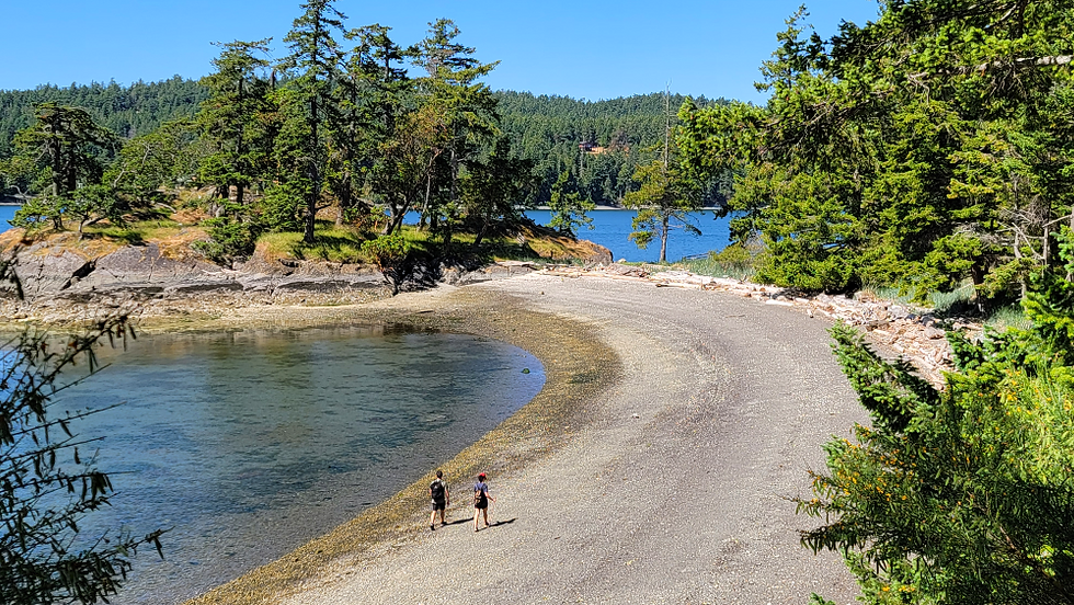
Hikers stroll along the larger of two crescent-shaped Beaumont Marine Park beaches. Parks Canada-protected Beaumont Peninsula is at the far end.
BEAUMONT MARINE PARK TRAIL
Cliffside Trail/Ainslie Point Road Trailhead
Gulf Islands National Park Reserve (GINPR)
RP’s Last Visit: May 13, 2026
Overview
Technically, this hike is through two parks: the first 100 metres (approx. 110 yards) on the Pender Islands Parks and Recreation Commission (PIPRC) Cliffside Trail and the balance in Parks Canada’s Beaumont Marine Park. And they couldn’t be more different and still jaw-droppingly spectacular. The short Cliffside Trail features numerous stairs—earth and wood or conglomerate rock construction—and massive rock cliffs and moss-covered boulders with scattered Arbutus and a Salal and Oregon Grape ground cover. The predominant Beaumont Marine Park Trail twists and turns through a variety of conifers (with Mr. Norman to the north), arriving at the mesmerizing Bedwell Harbour beaches. The trails are clearly defined and easy to follow (020325).
Update. During the past few springs, the Cliffside Trail has been chained and signed temporarily closed to “PROTECT SENSITIVE BIRD NESTING HABITAT.” Should this occur on your March-May visit, walk/ride/drive back up Ainslie Point Road to the Beaumont Marine Park/Mount Norman Ainslie Point Road trailhead (Trailhead Coordinates: 48.76360, -123.25266) and follow the GINPR sign maps to the Beaumont Marine Park Trail. See the Note at the end of this page for more details.
Beaumont Marine Park Trail FACTS
Distances and elevations vary depending on the GPS tracker devices and digital mapping software used.
Best time of year: Anytime.
Difficulty Rating: MODERATELY STRENUOUS
Trail Type: OUT & BACK
Distance (Garmin): 4.6 km (approx. 2.85 mi)
Time Allowance: 1.5 hours
Highest Elevation (Garmin): 109 metres (358 feet)
Lowest Elevation (Garmin): Sea level
Dogs Permitted: Yes, on leash at all times
Amenities: Pit toilets (compost toilet near main crescent-shaped beach closed as of May 13/26), benches, ocean beach, Parks Canada information stations, NO camping (Parks Canada information stations and bike rack at Mt. Norman/Beaumont Marine Park access off Ainslie Point Road)
Freshwater Availability: No
Cell Service: Some hikers report needing U.S. roaming to receive service between Beaumont’s main crescent beach and the end of the trail nearest Poets Cove Resort & Spa
Parking: Cul-de-sac at the south end of Ainslie Point Road (please don’t block private driveways)
Travelling to the Trailhead: By vehicle—4.1 km (7 minutes) from Driftwood Centre (left on Canal Road, right on Ainslie Point Road on the south side of the Canal Road Bridge; follow Ainslie Point Road to the cul-de-sac; On foot—Car Stops at the Driftwood Centre, Woods on Pender, and on Canal Road in front of the Pender Islands School and Pender Islands Health Centre.
Birders: 79 species since 1989 (eBird)
Trailhead Coordinates (Ainslie Point Road): 48.76161, -123.25289
RELIVE 3-D map of the Beaumont Marine Park Trail: The elevation gain displayed at the end of a Relive video refers to the total vertical distance gained during your hike.

Tug at the top of one of the Cliffside Trail’s conglomerate rock staircases (112621).
Route Description
Cliffside Trail Beginning
A Cliffside Trail signpost on the southeast end of Ainslie Point Road marks the start of your hike and an immediate climb up twenty-five PIPRC-trail-staff-manufactured earth steps. This is just the first of a series of earth or conglomerate rock stairs along the Pender Islands Parks and Recreation Commission’s 100-metre (110-yard) portion of the trek to Beaumont. This section highlights the PIPRC trail builder’s artistry—particularly his chiselled rock steps.
The Cliffside Trail ends at a sign spelling it out. But the single track pays no heed, leading to a fork in the path: left, taking you to more earth stairs and a challenging climb to a junction with the Mt. Norman trail; right, down Beaumont’s switchback section through primarily Douglas fir, and occasional samples of Arbutus and of Big Leaf maple and a ground cover of Salal. The zig-zagging ends at the north side of the Bedwell Harbour shoreline and the first of the resting benches, 30 metres (approx. 100 feet) above the sea.
A short distance south, a Parks Canada sign offers hikers access to a small peninsula off the main trail, one of several shoreline viewpoints. A bench marks the spot for a rest or picnic. But don’t leave your food unattended; a family of four or five River otters live nearby and is regularly seen on the shoreline rocks or swimming, looking for their next meal. Gulls, crows, ravens, and Bald eagles are also lurking, ready to snatch your hiking snacks.
The trail follows the Bedwell Harbour shoreline through a forest with more Arbutus and Big Leaf maple prevalent, to a third resting bench and a pretty view of the harbour and North Pender and a small but striking meadow of pink-flowered Sea Blush (April-June). The trail turns inland a bit before it forks. Tug always stopped at the split, awaiting word on the direction. Usually, we continued straight, returning via the alternate trail nearer the ocean.
The ocean disappears, and Mount Norman’s southwest-facing base becomes visible between larger, taller, 100-year-old or more Western redcedars and Douglas firs; Big Leaf maple breaks up the dominance of these species. The enormity of the trees darkens the atmosphere. Listen to the sounds of nature, eyes closed. When you open them, look up at the magnificent blue sky seen through the treetops.
Some decaying tree stumps exhibit springboard logging marks from the late nineteenth and early twentieth centuries. The often massive flared butts of old-growth redcedars and firs made for arduous sawing, so early loggers notched the trunk above the flare. They inserted a board to stand on and chop. The springy boards gave the method its name.

Springboard logging mark on an old Douglas fir stump alongside the Beaumont Marine Park Trail.
Much of the Southern Gulf Islands’ forest floors have a shallow layer of soil atop rock. The trees are poorly anchored and frequently topple during intense wind events. Fallen trees and their exposed roots are a common sight on the islands. An estimated 5,000 trees were blown down on Salt Spring Island in 2018. I hiked the Mount Erskine trail system shortly after, and the forest floor was littered with downed trees.
A mess of trunks and branches can change a trail’s routing. When park maintenance workers can’t easily cut a chunk of a trunk for continued access, they must redirect the trail. This has happened numerous times along the Beaumont Marine Park Trail during my 21 years of visits. Tug and I always steered clear when the wind blew over 40 km/h (approx. 25 mph). Massive falling trees are a real danger to hikers.
The Beaumont beaches
A Parks Canada sign and a composting toilet (May 13/26: toilet structure marked closed by pink barrier tape) perched on the south side of the trail mark your arrival at Beaumont’s two crescent beaches. Tug and I have always delayed venturing onto the rock-and-shell beaches for a walk and swim until returning from the far east end of the trail and another beach and the national park’s boat anchoring buoys.
Past a guardrail, the path follows the bluff 15-20 metres (approx. 50-65 feet) above the Bedwell Harbour shoreline. Two seat-backed wooden benches look southwest at Skull Islet, where the ever-present gulls and crows are visible. Watch closely for a “resident” Great Blue heron stalking its miniature prey and Pacific harbour seals lolling in the shallows. Skull Islet’s red-and-white navigational marker was recently replaced, and the tent camping sites near the outhouses were closed. A promising-looking path beyond the second outhouse dead ends. The land mass on the southwest side of Skull Islet is North Pender Island (Trincomali), and situated near the mouth of the harbour is Poets Cove Resort & Spa.
A big surprise awaited me on a February 2025 trek to the end of the trail—by the pit toilets and Mount Norman/Beaumont information station (tide charts and anchorage buoy details)—the staircase to the beach was gone! Rather than descend the two-dozen wood steps to the ocean and a cool-off swim, Tug would have effortlessly scampered down the crumbling earth and rock cliff face. My reality was more challenging. I managed it and, in Tug’s honour, walked the water’s edge to the Arbutus terminus and the multiple scraped lovers’ initials in its trunk and limbs. So far, the GINPR/Parks Canada has chosen to replace the vanished staircase with a knotted climbing rope and a caution sign (Beaumont Mooring Area: Stairs Removal). A poor accessibility choice by anyone’s standards.
At low Summer tides, balance-savvy hikers can backtrack to Beaumont’s crescent beaches via the sometimes slippery and always dangerous “bike chain” rock shoreline. Otherwise, retrace the bluff path above.
Whether you take the low or high road, you’ll arrive at Beaumont’s gem: the spectacular south-facing crescent-shaped rock and shell beach, jumbled with driftwood to sit on or lean against and transparent seawater to dip in (best to wear footwear for protection from broken clam shells and barnacles). There’s no better place in the Southern Gulf Islands to picnic or snooze. And it’s the quintessential log walking spot. Be careful, though, when stepping on wet logs. I’ve seen some nasty falls.
Please respect the Parks Canada “don’t go” sign on the split-rail fences above the driftwood array. The former oceanfront campsites are barricaded to protect a one-time First Nations settlement. Archeologists uncovered culturally significant artifacts in the camping area and along the bluff overlooking Skull Islet. This resulted in the no-camping policy being in effect. Restoration of the heritage area is planned for a future date. Beaumont Peninsula, attached to the southwest end of the beach, is off-limits to humans to guard sensitive plant life.
I used to kayak from North Pender’s Medicine Beach to Beaumont with our pug, Mugsy. We’d hike Mount Norman, return to our oceanfront landing site for an overnight in our tent, and paddle home the next day. Camping at Beaumont was a favourite among SGI paddlers (and bikers and hikers). Once, I encountered hikers transporting their camping gear in a wheelbarrow! Hike the Beaumont Marine Park Trail to see how crazy this is.

S.A.L.T.S tenders and crew arriving at Beaumont’s smaller protected beach (BMP).
Landing at Beaumont by boat
Beaumont Marine Park beaches are popular day-trip destinations for sail and power boaters anchored in national park waters or docked at Poets Cove. On a nice summer day, tenders are tied to drift logs in multiple spots. The pilgrimage to the Mount Norman summit is a must-do for many visiting boaters.
On the north side of Beaumont Peninsula, across a shell midden from the crescent beach and below a beautifying-only split-rail fence, is a small beach well-protected from wind and waves. Some say the ocean water is warmer here. Besides me, I’ve only seen a few adults willing to brave the elements; two stand out: a snorkeler exploring in a 5mm wetsuit and an inter-island kayaking couple bathing naked after a long jaunt from Saturna Island. Uninvited, Tug joined them. A disused Beaumont Marine Park information and camping fee station stands on the grassy side of the split-rail fence, more or less adjacent to the old main campground.
The trek out
Our return trek to the Ainslie Point trailhead begins on a trail into the forest from the overgrown camp area (not the path to the compost toilet). Many people avoid this path during the wettest times in winter. The first few hundred metres can be mucky and slippery. Waterproof footwear with good treads is critical. As the ground dries, the trail enters a section of dense Salal, growing to 5-6 feet tall. Salal berries are plentiful in season. Their flavour isn’t for everyone, but they’re a favourite of mine. An off-shoot trail to Bedwell Harbour affords a view of the shoreline. Watch for River otters, Pacific harbour seals and Great Blue herons near the water’s edge.
At the Caution Steep Trail sign, where Tug stalled earlier, waiting for me to pick left or right, you should turn left and follow the inbound portion of the Beaumont Marine Park Trail out. When leaving the shoreline at the start of the switchback trail, a well-trodden spur trail heads west to a Parks Canada boundary sign and, beyond, Private Property. Please comply with the property owner’s wishes and don’t trespass. There’s nothing to see anyway.
The switchback section is more demanding on the way up than it was on the way down. Turn left at the short extension before the earth steps and retrace your route along the community park’s Cliffside Trail to the Ainslie Point Road beginning.
Note. Hikers can proceed past the extension connecting to the Cliffside Trail and climb the GINPR path, which ascends through three short but technical sections. They’re breathtaking for their physical challenge. Be cautious of your foot placement and balance here, as well as along the rocky trail back to its junction with the Mount Norman viewpoint hike. When you’re fatigued, it’s easy to misstep and fall. A few years ago, a hiking acquaintance tripped and fell along this part of the trail, requiring minor first-aid care by yours truly. Turn left at the Mount Norman sign to reach the Parks Canada parking area on Ainslie Point Road (trailhead marked by a yellow metal gate); Trailhead Coordinates: 48.76360, -123.25266.


