Spending time in nature
is good for our health.


The BEST
WALKS & HIKES
SALT SPRING ISLAND
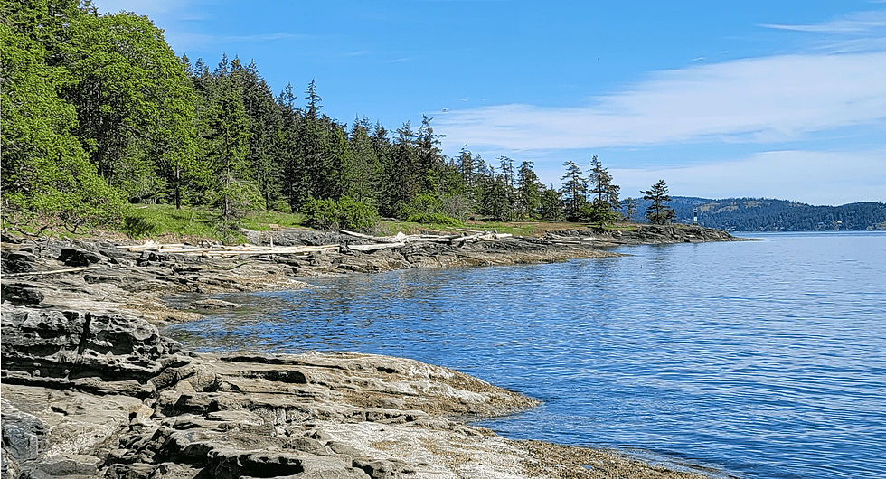
The south-facing Ruckle Provincial Park oceanfront campground (050625).
Photographs, videos, audio, and text Copyright © 2026 Richard Philpot/SGIOUTSIDE.ca.
SALT SPRING’S BEST
HIKES
Baynes Peak/Mount Maxwell Park/Girlfriend (#3) Trailhead (BC Parks) from Burgoyne Bay Park (follow #3 to #4, turn left/west to Baynes Peak • Last hiked by RP: January 2026 • Up & Back • STRENUOUS • MAP • Burgoyne Bay Trailhead Coordinates: 48.79398, -123.51980 • 14 km (approx 8.7 mi) • 2.5-3 hrs • Highest Elevation: 567 m/1,860 ft (Gain: 501 m/approx. 1,644 ft) • Parking at Burgoyne Bay • Amenities: Other hiking trails (see MAP), interpretive signs/maps, picnic tables, benches • NO fresh water or camping • Dogs on leash • Birders: 87 species since 1985 (eBird) • Highlights/Notes: Significant Garry oak meadows; sweeping viewpoints along #4 and left off side trails (see all the way to Vancouver’s North Shore Mountains and Washington State’s Mount Baker) • Best time of year: Anytime the sky is clear to see the incredible summit view south over the Burgoyne-Fulford Valley, Fulford Harbour, and more of the SGI, and west at Burgoyne Bay, Sansum Narrows, and Vancouver Island’s Maple Bay.
Mount Erskine Park (BC Parks) via Trustees Trail • Last hiked by RP: January 2026 • Loop with short Out & Back • STRENUOUS • MAP • Short Mount Erskine Upper Access Park Reserve/Dodds Trail (CRD) links to Mount Erskine trail system • Trailhead Coordinates: 48.85302, -123.54132 • Follow trail #2, #1, and #3 up, and and #2 down • 4 km (approx 2.5 mi) • 1.5-2 hrs • Highest Elevation: 423 m/1,388 ft (Gain: 226 m/approx. 741 ft) • Road parking for 12+ cars at Trustees Trail turnaround • Amenities: None • Dogs on leash • Birders: 75 species since 2015 (eBird) • Highlights/Notes: Rosie’s bowl and notebook at the summit and a glorious northwest view (clockwise) of Sansum Narrows, Maple Mountain, Crofton, Chemainus, Mount Arrowsmith, Tent and Penelakut Islands, Booth Bay and St. Mary Lake on Salt Spring, and Wallace Island, Trincomali Channel, Galiano and Valdez Islands, and the BC Lower Mainland • Best time of year: Anytime.
Reginald Hill Trail (SSIPARC/CRD) • Last hiked by RP: December 2025 • Up & Back • STRENUOUS (loose rocks and tree roots on trail) • Trailhead sign just off Reginald Hill Road • MAP • Trailhead Coordinates: 48.76699, -123.43877 • 2.6 km from trail sign (approx 1.6 mi) • 1-1.5 hrs • Highest Elevation: 183 m/600 ft (Gain: 127 m/approx. 417 ft) • Parking for a dozen cars at the south end of Morningside Drive next to the mailboxes • Amenities: None • NO fresh water • No camping, no smoking, no bikes on trail • Dogs on leash • Birders: 57 species since 2023 (eBird) • Highlights/Notes: Easy 1.1 km walk from Fulford Village; spectacular 180-degree SW-facing summit view of Fulford Harbour and beyond, a nice grouping of Arbutus at the summit, and a wonderful picnic spot • Best time of year: Anytime.
Ruckle Park/Heritage Farm & Campground Loop (BC Parks) • Last hiked by RP: August 2025 • Loop • EASY • MAP • Trailhead Coordinates: 48.77350, -123.37668 • 4-4.5 km (approx. 2.5 mi) • 1-1.5 hrs • Highest Elevation: 42 m/138 ft; Lowest Elevation: Sea level • Start at lower parking lot (information sign/map) • Amenities: Farmstand, farm animals, historic buildings, history/interpretive signs, pit toilets, campground, picnic tables, resting benches, bike racks • Birders: 154 species since 1979 (eBird) • Highlights/Notes: Spectacular walk in arguably BC’s prettiest campground and picnic area; no dogs permitted in active farm area and on a leash at all times in campground and on trails • Best time of year: Anytime.
W̱EN,NÁ,NEĆ Tsawout First Nations Trail (Tsawout pronounced “say out”) • Last hiked by RP: December 2025 • Out & Back or Loop • EASY • Trailhead sign at the end of Menhinick Drive • Trailhead Coordinates: 48.75757, -123.42158 • 1.6 km to north end trailhead sign or 4 km loop (approx 2.5 mi) along inland trail • 1.5 hrs • Highest Elevation: 95 m/312 ft; Lowest Elevation: Sea level • Limited road parking on Menhinick Drive • Amenities: Access to several beaches, resting bench • NO pit toilets • No dogs, no camping, no bikes, no fires • Birders: 51 species since 2024 (eBird) • Highlights/Notes: An often unvisited gem of an oceanside trail; please do not disturb or remove artifacts • Best time of year: Anytime.


CRD - Capital Regional District
GINPR - Gulf Islands National Park Reserve
SSIPARC - Salt Spring Island Parks, Arts, Recreation & Culture