Spending time in nature
is good for our health.


The BEST
BIKING
SALT SPRING ISLAND
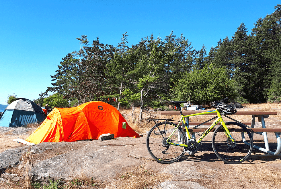
Spectacular nearshore ride-in-access camping in Ruckle Park, Salt Spring Island (081820).
Photographs, videos, audio, and text Copyright © 2026 Richard Philpot/SGIOUTSIDE.ca.
Important Safety Information: 1) If arriving in Fulford Village by ferry, WAIT on the Salt Spring Harbour Authority dock or grab food/supplies at Salt Spring Mercantile and Rock Salt Restaurant & Cafe until all unloading and loading ferry traffic is complete; only then proceed up to and along Beaver Point Road. 2) The best time of day to ride on Salt Spring is early morning. 3) Weekend and summer traffic can be very heavy. 4) Riding between Fulford Village and Gangesalong Fulford-Ganges Road is a hair-raising experience; too many local drivers and visiting trucks travel at outrageous speeds and pass bikes on blind corners with little regard for there own safety or the well-being of the cyclists (if you must ride from village to town or vice versa, take the alternate route along paved Beaver Point, Stewart, and Beddis Roads; otherwise, load your bike on the BC Transit bus racks and sit back and enjoy the scenery).
Island Pathways’ Salt Spring Island on Wheels cycling map is available to purchase for $15.50. Download their Heritage Map with Bike Routes (no longer available for purchase).
SALT SPRING'S BEST
Fulford Village to Ruckle Park • Last biked by RP: May 2026 • There & Back • MODERATE • MAPS: Ride with GPS and Salt Spring Island on Wheels on the Rock Salt Cafe exterior wall in Fulford Village • Starting/Finishing Coordinates (Salt Spring Mercantile parking lot): 48.769317, -123.449374 • 9.3 km one way (approx. 5.8 mi) • 45 mins • Provisions/Amenities: Salt Spring Mercantile and Rock Salt Restaurant & Cafe in Fulford Village, numerous roadside farm stands (including the Salt Spring Island Fruitsicles stand) along Beaver Point Road, freshwater swimming at Stowell Lake Beach (1.7 km from Fulford Village), Ruckle Park farmstand, campground, pit toilets, and hiking trails • Fresh water: Fulford Harbour, Ruckle Park • Birders (Ruckle Park): 155 species since 1979 (eBird) • Highlights/Notes: One of the most popular rides in the SGI; fairly steep climb out of quirky but quaint Fulford Village, followed by a mostly rolling road to Ruckle Park; spectacular walk into arguably BC’s prettiest campground and picnic area in Ruckle Park (read Two grandmas’ favourite walk); numerous other hiking trails; a five km round-trip detour down Bridgman Road and Menhinick Drive takes you to the W̱EN,NÁ,NEĆ Tsawout First Nations Trail • Best time of year: Spring and fall.
If you’re dead set on riding more on Salt Spring. Two I’ve done and enjoyed.
North End Loop (via Long Harbour, Robinson, Walker Hook, North Beach, and North End Roads, Sunset Drive, Vesuvius Bay, Upper Ganges, and Long Harbour Roads) • Counterclockwise Loop • STRENUOUS • MAP: Ride with GPS • Starting/Finishing Coordinates (Long Harbour Ferry Terminal): 48.851528, -123.445695 • 34 km (approx. 21.1 mi) • 2.5-3 hrs • Provisions/Amenities: Stores, restaurants, and bathrooms Ganges and Fernwood • Fresh water: Long Harbour, Ganges, and Fernwood • Birders (Wellbury Bay Park/Long Harbour): 54 species since 2021 (eBird) • Highlights/Notes: The quietest and least trafficked part of the island; the first 3.8 km include two tough climbs; the 6 km stretch through Fernwood is the only biking route on Salt Spring that hugs the shoreline, with terrific views east; start early in the day to maximize time in the morning sun; the north and west side of the route passes by several large sheep and horse farms • Best time of year: Anytime.
Long Harbour to Baynes Peak Summit/Mount Maxwell (via Fulford-Ganges, Cranberry, and Mount Maxwell Roads) • There & Back • STRENUOUS • MAP: Ride with GPS • Starting/Finishing Coordinates (Long Harbour Ferry Terminal): 48.851528, -123.445695 • 16.7 km one way (approx. 10.4 mi) • 90 mins • Provisions/Amenities: Stores, restaurants, and bathrooms in Ganges • Fresh water: Long Harbour and Ganges • Birders (Mount Maxwell): 88 species since 1996 (eBird) • Highlights/Notes: The incredible Baynes Peak Summit view of Burgoyne-Fulford Valley, Fulford Harbour, and more of the SGI, and west at Burgoyne Bay, Sansum Narrows, and Vancouver Island’s Maple Bay; extensive Mount Maxwell Park trail system; the grunt ride along pothole-laden Mount Mawell Road is worth it for the summit view • Best time of year: Anytime it’s dry and the sky is clear.


The last time SGI OUTSIDE’s Richard Philpot (RP) rode this route is next to its name.