

You’ll be green with envy if you skip the Greenburn Lake hike
- Richard Philpot

- Apr 12
- 7 min read
Updated: May 16
An abundance of wildflowers and a panoramic vista distinguish the Greenburn Lake hike from the trek around Roe Lake, the other freshwater lake on the Penders. The wildflower array at Greenburn is lovely from April through July, particularly along the north side of the lake, at the high-elevation bluff viewpoint, and near the bridge in late June and early July.
Table of Contents
Photographs, videos, audio, and text Copyright © 2026 Richard Philpot/SGIOUTSIDE.ca.

Yellow Flag (invasive) and Yellow Pond Lily dominate Greenburn Lake’s east end from mid-May through June (071323).
GREENBURN LAKE TRAIL (South Pender Island)
Gowlland Point Road Trailhead
Gulf Islands National Park Reserve (GINPR/Parks Canada)
RP’s most recent visit: May 7, 2026
Overview
Long-legged waders, tree-clingers and perchers, ducks, and soaring birds frequent this mountain lake and the nearby bluff. Great Blue herons and Bald eagles are often heard before being seen. The 180-degree view from the bluff is stunning, looking at the US San Juan Islands, more of the Southern Gulf Islands, and Vancouver Island. The rocky trail section on Greenburn’s north side is challenging, so skip it unless you are fit, are wearing good shoes, and are carrying your hiking essentials. Inexperienced hikers not used to trekking on wet rocks may want to wait for a nice, dry day in Spring, Summer, or early Fall. The south side of Greenburn Lake is an easy walk.
Greenburn Lake Trail FACTS
Distances and elevations vary depending on the GPS tracker device and the digital mapping software used.
Best time of year: Anytime, but preferably in dry weather.
Difficulty Rating: MODERATE (technical in places)
Trail Type: Out & Back and Loop around Greenburn Lake (with an extension to the bluff)
Distance: 4.4 km (approx. 2.7 mi)
Time Allowance: 1.5 hours
Highest Elevation: 124 metres (407 feet)
Lowest Elevation: 65 metres (213 feet)
Elevation Gain: 59 metres (194 feet)
Dogs Permitted: Yes, on a leash at all times*
Freshwater Availability: None*
Amenities: None
Travelling to the Trailhead (Google): By vehicle—12.9 km (19 minutes) from Driftwood Centre: South to Canal Road (turn left); Canal Road becomes Spalding Road at 8.4 km and turns into Gowlland Point Road at Poets Cove Resort & Spa
Parking: In front of the Church of the Good Shepherd Anglican Church (.23 km away, near the Poets Cove Resort & Spa entrance sign); PLEASE DO NOT park in the Pender Island Fire Rescue Hall No. 3 parking lot (penderfire.org) next to the trailhead
Bike or Foot Travellers: Lock your bike to the church fence or trailhead gate; Car Stops on each side of Gowlland Point Road in front of the church
Trailhead Coordinates/Google Maps (Gowlland Point Road): 48.745000, -123.220583
Birders: 110 species since 2004 (eBird)
*See the GINPR public health advisory sign BELOW describing the potential harm to humans and animals from consuming Blue-green-algae-infected Greenburn Lake (020926).

Route Description
The Greenburn Lake Trail begins from Gowlland Point Road just west of the South Pender Island Firehall. It’s hard to miss the Parks Canada sign and bright yellow metal gate with an attached no-parking sign. The trailhead gate looks more like a vehicle-traffic barrier than access for two-legged travellers.
The best place to park your car or truck is in front of the Church of the Good Shepherd, next door to Poets Cove Resort & Spa (junction of Spalding Road and Gowlland Point Road). There’s room for half a dozen vehicles to parallel park between the paved road surface and the fence surrounding the Anglican Church property. The walk from the church to the start of the trail is five minutes (10 minutes from Poets Cove Resort & Spa).
Whether you begin from Poets or the church, be sure to take a few minutes to read the W̱SÁNEĆ First Nations interpretive sign explaining The Thirteen Moons of the W̱SÁNEĆ Year and providing a condensed history of the W̱SÁNEĆ people.
Follow Gowlland Point Road east from the church toward the Pender Island Fire Rescue Hall No. 3, the grey building with red trim at the curve in the road. The yellow gate indicates you’re in the right place.
The stretch of trail from here to the lake is a 3-4 metre (10-13 feet) wide, hard-packed gravel road, climbing through second-growth Douglas fir, Western redcedar, and Big Leaf maple forest. Until recently, Parks Canada twice gave notice that they’re watching you: signs mounted to trees advised hikers that hidden wildlife cameras in the area are snapping daily pictures (0700 and 1900). Parks Canada claimed these WEREN’T motion-activated cameras and that they deleted photographs of people taken inadvertently. Should naturalist hikers, skinny dippers, and open-air lovemakers be alert to the possibility that a camera was overlooked? And their illegal activities are still being recorded?
The “road” levels out for the final .5 km to the Greenburn Lake Dam. The manufactured dam, which also serves as a bridge, defines the west end of the lake (the water source for Poets Cove). If you choose to circle the freshwater reservoir clockwise, proceed straight ahead until the wide trail turns to a narrow, single-track path along the lake’s northern boundary. Only reeds and Bull Rushes separate you from the water. The view is gorgeous.
A Parks Canada sign—Caution! Risk of injury from falling rocks—marks the trail’s transformation into rocky, technical terrain. A walking stick or pole is a MUST. Be sure to securely plant your pole tip before shifting your weight. Well-fitted, grippy-soled footwear is equally essential gear. Pay close attention when placing your footsteps; it’s easy to be distracted by looking down at the lake or up at the wildflowers and the massive rock formations. It’s reasonable to use the trail’s rocks to maintain your balance, but before you pull on or use one to support your body weight, ensure it’s secure by giving it a wiggle test. It’s slow going on the north side of the lake due to the need for attentive climbing.

ABOVE: The start of the Greenburn Lake Trail’s rocky north shore section and Parks Canada’s caution sign. BELOW: Red Paintbrush, found on the north side, is one of the many wildflowers found along Greenburn Lake and the trail to the bluff lookout.

The trail returns to mostly packed earth near the east end of the lake, where the path splits. They rejoin in less than a minute. Don’t take either trail heading further east, as they lead to private property. Getting to the end of Greenburn Lake is always emotional. A good friend lived on a property adjoining the park. We miss him dearly and always say hello when reaching this point in the hike.
The water’s-edge trail forks at the two-kilometre mark, where beavers have downed, and wind has felled nearshore trees. Round behind the uprooted Douglas fir to the trail westbound along the shoreline. The walking is easy, with occasional protruding tree roots and no climbing. Winter brings wild mushrooms. The “shrooms” are intriguing, but it’s best to refrain from touching or eating them unless you’re knowledgeable. Some are poisonous to the touch; others, if consumed, can make you quite ill or kill you.
Views of the lake are increasingly blocked by trees as you pass through the ground cover of Salal, Sword fern, and Oregon Grape, shrinking the path. A once well-hidden, moss-covered, horizontal tree stump protruded from the matching-colored foliage into the trail. I walked into it several times despite knowing it was there. Parks Canada trail maintenance staff have since removed the hazard.
Relax and enjoy the forest’s serenity. The tree canopy provides welcome shade during hot summer days.
The trail narrows, skirting the edge of a tiny marsh on the off-lake side. The grassy pond is clearly marked by the finest display of beaver art in the Southern Gulf Islands: a Big Leaf maple with a chunk chiselled from its trunk courtesy of you know who. How long did it take the local crew to whittle the tree’s main stem to that size? Parks Canada staff have assured me they don’t and won’t trap beavers residing here or at Roe Lake.

Big Leaf maple with a chunk chiselled from its trunk courtesy of you know who.
Greenburn Lake Sidetrack
Veer away from the lake at the fork in the trail for a 5-10 minute out-and-back sidetrack. In no time, you will see evidence to the south that the ocean is nearby. Ignore the side trail that passes very close to the edge of the rocky bluff; stick to the alternative, following it to a safer vantage point to enjoy the high-peak scenic view. Grass species are present for the first time on the hike at this park-like clearing atop a conglomerate rock bluff, 124 metres (407 feet) above the South Pender shoreline. The 180-degree panoramic view is SPECTACULAR! If you’re afraid of heights, remain safely away from the bluff’s edge. A long-downed tree is a good resting and picnic spot. High-flying Turkey vultures and Bald eagles often drift at eye level in the updraft (your eye level). A trail continues northwest from this viewpoint and picnic spot, but doesn’t lead to anything worth seeing; you’re better off returning to the Greenburn Lake loop trail.
Scanning from left to right, you see across Boundary Pass to the US San Juan Islands (Stuart Island and Turn Point Lighthouse are closest), Haro Strait, SGI’s Inner Islands, Moresby Island, Salt Spring Island, and Vancouver Island in the distance. The nearest land mass is the south end of North Pender Island. Most of the Canadian islands in the foreground are privately owned, except for Isle-de-Lis, Darcy Island, Sidney Island, Portland Island, and a few smaller islets, which are part of the Gulf Islands National Park Reserve.
If you picnic at the scenic viewpoint, you will see massive cargo ships stacked high with containers of consumer goods, bulk fluids, or grain. These vessels come and go between the North American coast and various Asian countries, turning east from Haro Strait into Boundary Pass on arrival and the reverse on departure, back out to the Pacific Ocean. The invisible US-Canadian border bisects Boundary Pass and Haro Strait.
Retracing your steps back to the main Greenburn Lake Trail, take a left turn for a short trek to a Parks Canada sign and the start of the 40-metre-long (131-foot) concrete Greenburn Lake Dam. The view east from the middle of the dam is beautiful. And tranquil.
Note. If you don’t have the energy, skills, or time to loop around the lake, proceed counter-clockwise across the dam and turn right at the first branch trail, leading to the high-peak viewpoint and picnic spot. This turns your adventure into an out-and-back hike, shortening the overall length to 1.6 km (1 mile) each way (25-30 mins). This abbreviated Greenburn Lake hike is still classified as MODERATE because you first must climb from Gowlland Point Road to the dam.
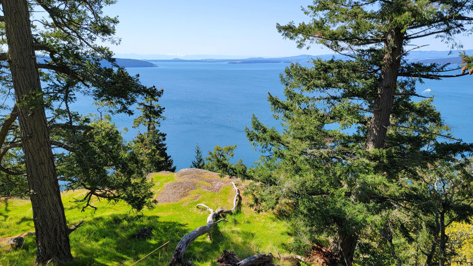
Panoramic south-facing view from the Greenburn Lake Trail sidetrack.

